描述
🗺️ Navigate like a pro—never miss your mark!
- BUILT TO ENDURE - Crafted from thick, waterproof plastic that resists yellowing and wear—your navigation ally for years.
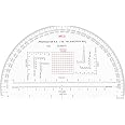
- TACTICAL DESIGN - 9-inch RA half-circle with integrated holes for plotting cords—engineered for hands-on field use.
- PRECISION PLOTTING - Accurately marked with mils and romer scales to ensure flawless bearing calculations every time.
- ESSENTIAL FIELD GEAR - Trusted by soldiers and cadets alike, this protractor is a must-have for confident land navigation.
- VERSATILE SCALE MASTERY - Seamlessly works with 1:25,000, 1:50,000, and 1:100,000 map scales for ultimate adaptability.
The CYA Military Map Protractor is a durable, waterproof navigation tool designed for professional land navigation. Featuring mils and romer markings, it supports multiple map scales (1:25,000 to 1:100,000) and includes a 9-inch RA half-circle design with plotting cord holes, making it an indispensable asset for military personnel and outdoor enthusiasts.