We remain fully operational. Our teams are working around the clock to ensure your deliveries continue safely.

DOWNLOAD THE APP


Customer Services
Copyright © 2025 Desertcart Holdings Limited
DOWNLOAD THE APP


🧭 Own the wild with precision and power — Garmin GPSMAP 65 leads the way!
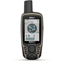
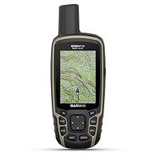
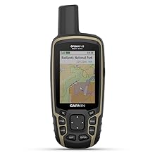
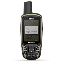
The Garmin GPSMAP 65 is a rugged, button-operated handheld GPS device featuring a 2.6-inch sunlight-readable color display, expanded global navigation satellite system (GNSS) support with multi-band technology for superior accuracy, and wireless connectivity via Bluetooth and ANT+. Designed for outdoor enthusiasts, it offers preloaded TopoActive maps and U.S. public land boundaries, runs on standard AA batteries for up to 16 hours, and integrates seamlessly with the Garmin Explore app to manage routes and waypoints on the go.

| ASIN | B08HR6587B |
| Are Batteries Included? | No |
| Audio Output Mode | Digital |
| Battery Average Life | 16 Hours |
| Best Sellers Rank | 30,016 in Sports & Outdoors ( See Top 100 in Sports & Outdoors ) 9 in GPS Handhelds |
| Box Contents | GPSMAP 65; USB cable; Carabiner clip; Documentation |
| Brand | Garmin |
| Brand Name | Garmin |
| Compatible Devices | Smartphone |
| Compatible with Vehicle Type | Truck |
| Connectivity Protocol | Bluetooth |
| Connectivity technology | ANT+ |
| Control Method | Push Button |
| Customer Reviews | 4.6 out of 5 stars 366 Reviews |
| Display Type | Transflective, 65K Color TFT |
| Human Interface Types | Buttons |
| Item Dimensions L x W x H | 16L x 6.1W x 3.6H centimetres |
| Item Type Name | Handheld GPS |
| Item Weight | 0.48 Pounds |
| Manufacturer | Garmin |
| Map Coverage Type | North America |
| Model Name | GRGPSMAP65 |
| Model Year | 2019 |
| Model name | GRGPSMAP65 |
| Mounting Type | Portable |
| Network Connectivity Technology | ANT+ |
| Operating Systems | Système d'exploitation Garmin personnalisé |
| Product Features | Expanded GNSS Support; Multi-Band Frequency Support; Preloaded Topo Maps; Public Land Boundaries; Smart Notifications; Geocaching |
| Resolution | 160 x 240 |
| Screen Size | 2.6 Inches |
| Screen size | 2.6 Inches |
| Special feature | Expanded GNSS Support; Multi-Band Frequency Support; Preloaded Topo Maps; Public Land Boundaries; Smart Notifications; Geocaching Special feature Expanded GNSS Support; Multi-Band Frequency Support; Preloaded Topo Maps; Public Land Boundaries; Smart Notifications; Geocaching See more |
| Sport Type | Camping & Hiking, Hunting, Outdoor Lifestyle |
| Supported Satellite Navigation System | GPS |
| Touch Screen Type | Capacitive |
| UPC | 753759257828 |
| Vehicle service type | Truck |
D**S
Comprehensive robust navigation compass and tracker
I have used Garmin dedicated GPS handheld receivers for many years as I value the extra security of a separate compass tracker to my smartphone. This model is robust and operates in all weathers and has an easy interface which I am used to from earlier models. With an array of different attachments, it is easy to carry and access whilst hiking. I create maps of the routes I follow using Basecamp and pairing with my smartphone adds extra useful functionality when archiving the hike details, and in creating new routes. As with previous models the convenience of standard AA batteries makes this a particularly practical choice. Installing an extra micro-SD card allows the flexibility to download maps of different European countries, an important aspect as I am based in the UK.
T**D
PERFECT GPS FOR GEOCACHING!
This is my third Garmin GPS, the other two both still work well but I just wanted to treat myself to a new one. I use it for geocaching as I much prefer the waterproof, tough, non-touch-screen, running on 2 Double A batteries (rechargeable) as opposed to walking round rough countryside carrying my phone and hoping I won't drop it on a rock, into water or thick mud! This GPS will survive all that and keep going!
Trustpilot
1 month ago
1 week ago